
Oregon Trail Rainbow
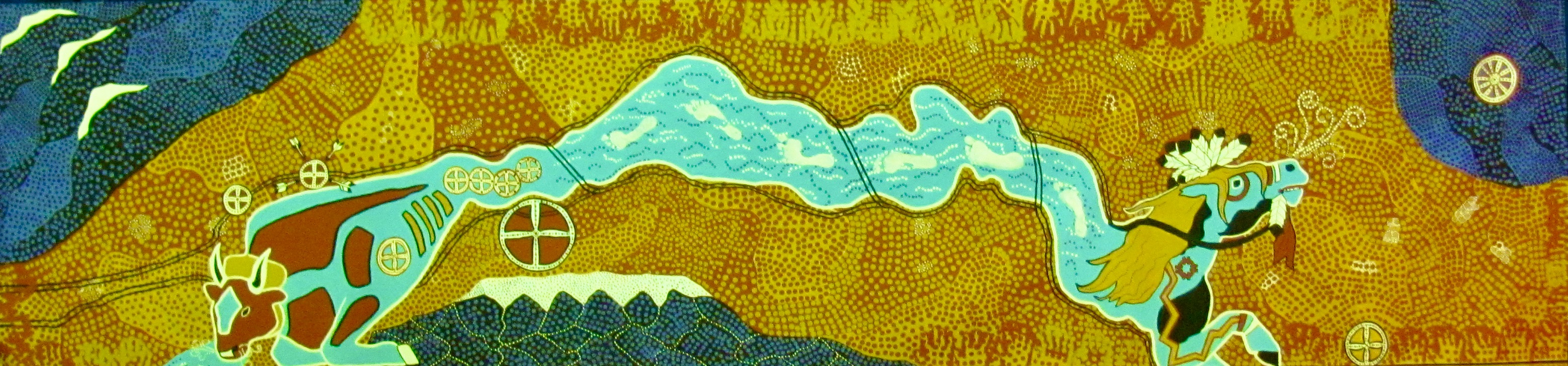
The focal point of our mural is our Rainbow Snake, based on Australian Aboriginal culture. The Rainbow Snake can change his headdress, and even wear two, as ours does. The number 4 is a constant throughout our mural. It represents the 4 trails, the 4 directions, and 4 sacred colors.
1. The headdress at the west end of the rainbow snake is the ox. The ox carried many of the pioneers west. He was gentle, faithful and sturdy. He wears a yoke, the item that connected him to the wagon. He is red, both because the most common breed of oxen carrying the emigrants was red, and because he symbolizes the red hills that kept the pioneers from following the Platte River any farther than they did. He has 4 ribs, 4 large muscles, and a 4 chambered stomach, representing the 4 trails. The ribs resemble wagon bows - both of them protect the important things inside the covering. The muscles remind us of the many islands that have formed in the Platte River.
2. The headdress at the east end of the rainbow snake is the war pony. While the various tribes of Native Americans in this area were friendly for a time, they began to tire of the invasion of their land. He is decorated in ways that symbolize the power of his rider. His feathers, the red cloth under his chin, and the painted marking show that he has been part of successful battles. He is heading towards the Black Hills, the sacred land of the Sioux.
3. The body of the Rainbow Snake represents the Platte River. The river was extremely important to everyone and everything in the area because its water gave life. The river is full of currents and channels, which gave the pioneers trouble when they crossed it.
4. The white footprints through the river represent the thousands of people who traveled along the river and relied upon it for life. They are the footsteps of our ancestors. Because they appear to be walking on water, they also represent the Christian religions that so many of the missionaries and pioneers brought to the west.
5. The 4 trails, the Oregon, California, Mormon, and Pony Express, are represented by the black, two-track lines following and crossing the river. Like the trails, some of the tracks follow along the south side of the river, and some follow along the north side of the river. Eventually, all of the pioneers have to cross to the north side. They have to be on the north side to leave the North Platte River and head for the Sweetwater River. The final crossing is at Bessemer Bend, right before the red hills that make it too treacherous to continue following the Platte. The black lines also resemble the barbed wire that came later, changing the land forever.
Sacred Sites
Wheels with 4 spokes represent all but one of our Sacred Sites. They bring to mind the many wagons that came through this area. Each one represents some place significant to this area.
1. Casper, Wyoming, our hometown, is represented by the largest of the circles. It sits right next to the Platte River, and the trails went right through the town.
2. The circle that is the heart of our ox is Oregon Trail Elementary, our special place. Our school sits right on the trail.
3. Northwest of our school, with 4 arrows pointing at it, is the site of the Battle of Platte Bridge. It was at this battle that Caspar Collins and most of his men lost their lives in a fight with a large party of Sioux and Cheyenne warriors. Our city gets its name from Lt. Collins.
4. Right near the Battle of Platte Bridge was the Battle of Red Buttes. These battles happened on the same day very near each other.
5. Ft. Laramie is shown near our war pony’s foot. Fort Laramie was an important site to both the pioneers and the Native Americans in the area. Most of the pioneers stopped at the fort to get supplies and mail. Many Indians lived around the fort, trading with those pioneers. Treaties signed at the fort affected the lives of the tribes living in our area.
6. The symbol in the Black Hills is a special tribute to our friend, Paul Taylor, who helped us create this mural. Sadly, he lost his father shortly before his week with us, and this is our way to pay tribute to him. The hub of the wheel represents Paul’s mother, who is the heart of the family. The outside rim of this circle represents Paul’s father, wrapping around the family to keep it safe. Connecting them is the spokes, of which there are 10, representing Paul and all his siblings. The wheel is located in the most sacred place to the Sioux, Mount Harney, the highest point in the Black Hills. This point also happens to be the place where Paul decided to stay in America and share his native country’s history with the children of America. It is also the childhood home of Anne Halle, our art teacher, the talented artist who designed our mural.
The Land
Our entire mural is a map, meant to represent the geography of our area. In addition to the river and our Sacred Sites, we wanted to show our beautiful surroundings.
1. To the northwest of Casper, the beautiful Big Horn Mountains rise up. Most of the year they are topped with snow. They were also called the Shining Mountains by some of the different tribes in our area.
2. South of Casper is our own beautiful Casper Mountain. It’s an old mountain with rounded tops and deep gullies and crevices. The pioneers called them the Black Hills, because of their dark color.
3. In the northeast is the real Black Hills. This area is sacred to the Sioux, and was the source of many conflicts between the whites and the Sioux. Like Casper Mountain, they are old, with rolling peaks.
4. In between the mountains, the great open plains roll on for miles. They are never flat, but are a series of hills and gullies that seem to go on forever. The dots on all the landscapes represent the raindrops that give us life, and all the people who have passed through.
5. Scattered throughout the plains are clusters of white dots. These represent the things that were troublesome and annoying to the pioneers passing through. This includes prickly pear cactus, sagebrush, alkali, and dust devils.
6. Wyoming is known for its wind in many places, especially in our area. Some days it is just a nice, gentle breeze, keeping us cool on a hot day. The soft puffs coming out of our gentle ox’s nose represents those breezes.
7. Some days, the wind blows with a vengeance. The powerful snort coming out of our fierce war pony’s nose represents the winds that chill us to the bone. Its strength and fury often surprises us.
The Hands
Almost 100 children helped create this mural. The 4th and 5th graders at Oregon Trail Elementary painted the mural by laying down the base colors, adding the dots, then putting on the final touches to bring the mural to life.
1. Each of the 5th graders’ hands, with their initial inside, creates a frame for our mural – the hands that touch the land.